The Illinois and Indiana tornado deaths show how quickly severe wind can outrun familiar warning routines. The storm toll drew national attention on March 12, 2026
Warnings Met a Fast-Moving Storm
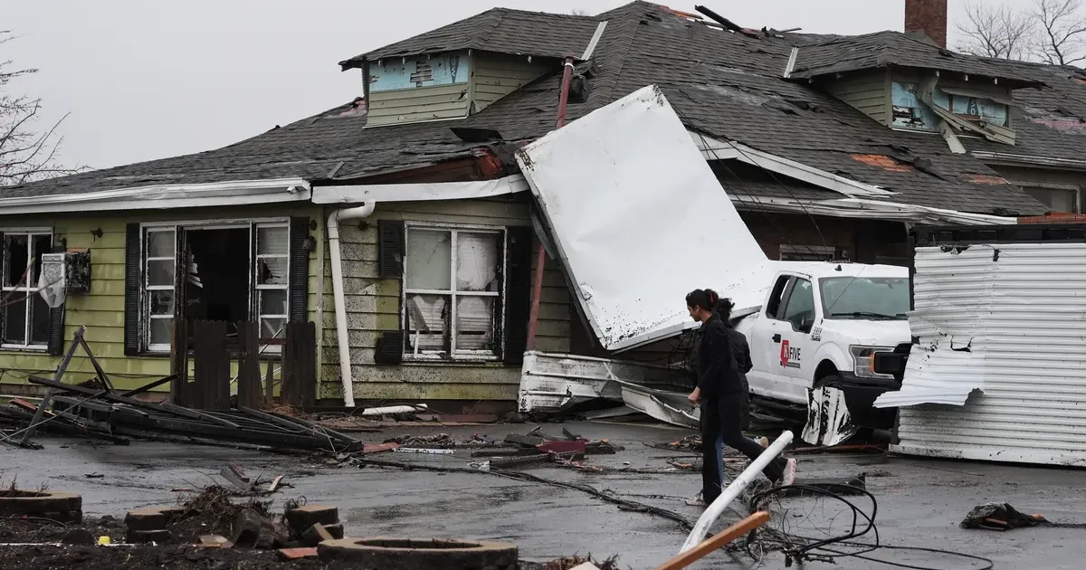
Kankakee residents faced a nightmare of twisting metal and splintered timber on Wednesday night when a violent storm cell carved a path of destruction through the region. High pressure systems colliding over the Great Plains forced unstable air into the Midwest, creating the perfect conditions for tornadic activity. Emergency responders in Illinois confirmed that at least two people lost their lives during the initial surge of the storm. These fatalities occurred when residential structures proved unable to withstand the sheer force of the rotating winds. Local authorities in Kankakee reported that the storm shattered windows, tore off roofs, and smashed vehicles across several neighborhoods. Residents spent the early hours of Thursday morning picking through the wreckage of what used to be suburban living rooms. Death counts often rise in the hours after initial impact assessments begin. Search and rescue teams continue to navigate piles of debris in Northwestern Indiana, where the same system caused significant structural damage to industrial and residential zones. Officials are now reviewing whether warning systems matched the speed of the outbreak. While the NY Post US News focuses on the immediate carnage in the Kankakee corridor, the broader scope of this meteorological event stretches far beyond the Illinois state line. The path of the tornadoes indicates a high-velocity system that maintained its strength long enough to catch many residents off guard despite advanced sirens. First responders describe the scene as a chaotic mix of downed power lines and ruptured gas mains, complicating the effort to locate potential survivors trapped in basements or crawl spaces. Meteorologists at the National Weather Service are tracking a separate but related phenomenon that has placed nearly half the United States under wind advisory warnings.
Damage Outran Local Capacity
Newsweek reports that winds could gust up to 100 mph in some areas, a figure usually reserved for Category 2 hurricanes. These gusts are not limited to the tornado-prone regions of the Midwest but are sweeping across the central and eastern portions of the country. High-profile travel hubs are seeing massive cancellations as officials urge citizens to delay all non-essential transit. Winds of this magnitude can easily overturn high-profile vehicles, making highway travel a life-threatening gamble for truck drivers and families alike.
Safety remains a privilege of those with sturdy basements. Airlines have already pre-emptively grounded hundreds of flights at O'Hare and Midway, fearing that the 100 mph gusts will make takeoffs and landings impossible. The economic impact of such a widespread travel shutdown is estimated to reach hundreds of millions of dollars in lost productivity and logistical delays. This atmospheric volatility is driven by an intense pressure gradient that has rarely been seen in the early spring months.
Such weather patterns typically arrive later in the season, yet 2026 is proving to be a year of early and aggressive transitions. Infrastructure in the Midwest is being tested to its absolute limit as power grids struggle to remain online under the pressure of falling trees and debris. Roads in Northwestern Indiana are currently impassable due to a combination of debris and ongoing high-wind hazards. Local police departments have issued stern warnings to rubberneckers and residents trying to survey the damage, noting that hanging branches and weakened structures pose a continuous threat.
Preparedness Has to Get More Practical
The physical damage in Kankakee is particularly severe, with entire blocks appearing as if they were subjected to targeted demolition. Vehicles were tossed like toys, some ending up hundreds of feet from where they were originally parked. This widespread disruption highlights the vulnerability of modern suburban construction to extreme wind events that seem to be increasing in both frequency and intensity. Power companies report that over 200,000 customers are currently without electricity across the Illinois-Indiana border.
Repair crews cannot safely ascend utility poles until the wind speeds drop below 40 mph, meaning many families will spend the coming nights in the dark and cold. This fatal combination of tornado damage and sustained high winds has created a dual-threat environment that emergency management agencies are struggling to contain. While local charities have begun setting up shelters, the ongoing wind advisory makes reaching these locations dangerous for those who have already lost their homes. The sheer geographic scale of the wind warnings, covering nearly half the nation, suggests a systemic weather event that will dominate headlines for the remainder of the week.
Insurance adjusters are expected to flood the region by Friday, though the damage is so extensive that total recovery will likely take years. Every shattered window and stripped roof is a financial and emotional blow to a community that was already struggling with economic shifts.
The Warning System Is Still Too Passive
Fatal tornadoes in Illinois and Indiana exposed the speed and danger of a broader severe-wind outbreak, but the deeper failure is how passive the warning system still remains. A siren is not a shelter. A phone alert is not a basement. Officials can issue perfect language and still leave people with nowhere realistic to go.
The disaster showed that wind risk is now an infrastructure and public-safety problem, not just a weather story. Communities need shelter access, siren coverage, mobile-alert redundancy, power resilience and emergency communication that works for people without cars, stable housing or reliable phones. Anything less is bureaucratic theater performed after the roofs are already gone.