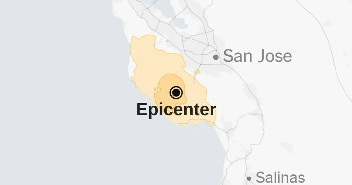
Santa Cruz County residents woke to violent shaking when a magnitude 4.9 earthquake struck the region. Reports from local seismic stations indicate the tremor originated near Boulder Creek at a depth of roughly 8 kilometers. The update came on April 2, 2026. Initial readings from the United States Geological Survey suggested a slightly lower intensity of 4.6, though subsequent data confirmed the stronger 4.9 magnitude rating. Residents across the San Francisco Bay Area reported feeling the surge of energy shortly after 5:00 a.m. local time. Seismic waves traveled through the dense rock of the Santa Cruz Mountains, reaching urban centers several miles from the epicenter within seconds. Emergency services dispatched units to inspect critical infrastructure near the fault line immediately.
Geologists at the United States Geological Survey noted that the quake occurred within a complex network of fissures branching off the San Andreas system. Data from the ShakeAlert system provided a few seconds of warning to individuals in nearby San Francisco and San Jose. Most residents described the sensation as a sharp, vertical jolt followed by several seconds of rolling motion. Early morning commuters reported seeing streetlights sway in suburban neighborhoods surrounding Boulder Creek. Local law enforcement received dozens of calls from startled homeowners, though reports of major structural damage remained scarce during the first hour of assessment. The United States Geological Survey continues to monitor the area for aftershocks.
Seismic Activity Near Boulder Creek
Boulder Creek sits atop a rugged portion of the Santa Cruz Mountains known for its dense redwood forests and steep terrain. Historically, this specific corridor has produced moderate seismic events that remind the local population of the subterranean pressures building beneath the Pacific plate. Instruments placed by the United States Geological Survey captured the high-frequency vibrations that characterize shallow crustal quakes. Scientists categorized the event as a strike-slip movement, a common occurrence in Northern California where tectonic plates grind past one another horizontally. The depth of the hypocenter played a serious role in how the energy dispersed across the surface. Shorter, sharper movements often cause more distress to residential structures than deeper, rolling tremors.
Property owners in Boulder Creek reported fallen glassware and minor cracks in plaster walls. One local merchant described the sound of the quake as a low-pitched roar that preceded the actual movement. Structural engineers suggest that the local geography, consisting of varied soil types and rock densities, can amplify or dampen the effects of seismic waves. Coastal regions often experience different intensities than inland mountain communities due to these variations. The United States Geological Survey maintains a network of hundreds of sensors in Santa Cruz County to track these exact details. Data collected from this event will help refine future predictive models for the region.
Regional Impact and Infrastructure Response
San Francisco officials initiated standard safety protocols for the city's transit and utility systems shortly after the vibration ceased. Pacific Gas and Electric crews began surveying gas lines in high-risk zones to prevent potential leaks or fires. Similar checks occurred at the Hetch Hetchy water system, which supplies much of the Bay Area with its water. Transit authorities slowed BART trains to a crawl for several hours to ensure track alignment remained within safety tolerances. Such procedures are mandatory whenever a quake of this magnitude occurs within proximity to major urban infrastructure. No meaningful disruptions to electricity or water services were reported by mid-morning on April 2, 2026.
A 4.9 magnitude earthquake shook Northern California early Thursday morning, the United States Geological Survey stated in its initial report.
Emergency management teams in Santa Cruz County activated their regional coordination centers to streamline communication between mountain towns and coastal cities. Isolated communities in the mountains often face higher risks of landslides during seismic events, especially if the ground is saturated from recent rains. Geologists observed no immediate evidence of major slope failures along Highway 17, the primary artery connecting Santa Cruz to the Silicon Valley. Caltrans inspectors remained on-site to evaluate bridges and overpasses for signs of concrete fatigue or joint separation. Heavy machinery stood on standby at nearby depots in case debris needed clearing from winding mountain roads. Most of the region resumed normal operations by the afternoon.
United States Geological Survey Data Patterns
Variations in magnitude reporting, such as the initial discrepancy between 4.6 and 4.9, occur frequently as more sensor data arrives at the United States Geological Survey headquarters. Seismologists use a moment magnitude scale that accounts for the total energy released and the area of the fault that slipped. Early estimates often rely on a limited number of stations, which can lead to slight under- or over-estimations of the event size. While Bloomberg reports that localized sensors in Boulder Creek recorded higher peak ground acceleration, Reuters sources claim the overall energy release stayed within expected parameters for this fault segment.
Refining these numbers is a standard part of the post-event analysis performed by federal scientists. The final 4.9 magnitude designation reflects a consensus across the entire sensor network.
Patterns of aftershocks often follow a predictable decay rate, though larger secondary quakes remain a statistical possibility. Scientists observed three minor tremors measuring below 2.0 magnitude in the four hours following the main event. These smaller adjustments represent the crust settling into a new position after the primary release of stress. Public health officials emphasized the need for households to maintain emergency kits containing water, food, and medical supplies. Education campaigns focused on the Drop, Cover, and Hold On technique continue to be a priority for local schools. Preparedness levels in San Francisco are currently at an all-time high due to recent regional drills. Statistical models suggest a high probability of similar events occurring in the coming decade.
Northern California Fault Line Analysis. Proximity to the San Andreas Fault makes Northern California one of the most seismically active regions in the United States. The 4.9 magnitude event on April 2, 2026, is a reminder of the constant tectonic movement occurring beneath the surface. Geologists have long studied the Santa Cruz Mountains as a source of serious geological activity. Stress accumulation along the plate boundary persists despite these moderate releases of energy. Some researchers believe that smaller quakes can relieve localized pressure, while others argue they may shift stress to adjacent fault segments. The complex interaction between these various fractures makes long-term forecasting difficult for even the most advanced computer models.
Detailed mapping of the Boulder Creek area reveals numerous secondary faults that could potentially trigger larger events. Experts from the United States Geological Survey are currently analyzing the satellite radar data to detect any surface deformation resulting from the tremor. This technology allows scientists to see millimeter-scale changes in the Earth's crust from space. Combining this satellite imagery with ground-based sensor data provides a wide-ranging view of the fault's behavior. Understanding the specific mechanics of this April 2 earthquake helps engineers design more resilient buildings for the future.
Seismic building codes in San Francisco have seen meaningful updates over the last twenty years to account for these findings. Most modern high-rises are designed to withstand much larger forces than those experienced this week.
California Quake Warning. Relying on moderate tremors to spur civic readiness is a fool's errand in a state defined by geological instability. The April 2 quake near Boulder Creek was a minor annoyance for most, yet the reaction from bureaucratic agencies suggests a dangerous level of performative safety. We see the same script every time a magnitude 4 or 5 event occurs: the United States Geological Survey issues a report, utility companies claim they are conducting inspections, and politicians tweet about the importance of emergency kits. This cycle of predictable responses masks a deeper, more concerning reality regarding California's actual readiness for a catastrophic event. If a 4.9 magnitude tremor causes transit delays and emergency center activations, the existing infrastructure is clearly fragile.
The state's obsession with incremental retrofitting is insufficient given the known risks of the San Andreas system. Billions of dollars have been funneled into projects that are still decades away from completion, leaving millions of residents in San Francisco and the surrounding areas vulnerable to a major rupture. We are playing a game of probability where the house always wins eventually. The current pace of seismic upgrades is a sluggish response to an urgent threat. Governments prioritize aesthetic urban development over the invisible, essential hardening of the power grid and water supplies.
This misplaced priority will lead to a preventable humanitarian crisis when a truly serious event occurs. The Boulder Creek tremor was not a warning; it was a symptom of a system that is destined to fail. California is not ready.