Emergency crews in Oklahoma City scrambled to clear debris on March 16 as a sprawling weather system surged across the central United States. The storm outbreak was reported on March 16, 2026, as severe weather battered millions across the United States. Millions of residents now face a complex array of meteorological threats ranging from lethal tornadoes to paralyzing blizzards. Low pressure systems are clashing with unseasonably warm air from the Gulf of Mexico, creating an atmospheric environment ripe for extreme instability. Experts at the National Weather Service issued warnings that cover more than a dozen states simultaneously. These conditions have forced local governments to activate emergency protocols typically reserved for peak winter or late spring. The West Coast is struggling with an intense heat dome that has pushed temperatures into the triple digits. This divergence in weather extremes highlights the erratic behavior of the jet stream during the transition from winter to spring. Heavy precipitation has already saturated the soil in the Ohio River Valley, raising fears of flash flooding as the main storm front arrives. Power lines have succumbed to high winds in several jurisdictions, cutting off electricity to hundreds of thousands of people. State police in multiple Midwest regions have advised all motorists to stay off the roads until visibility improves. High-velocity winds and heavy snowfall are making rescue operations nearly impossible in rural areas.
Storm System Hits Multiple Regions
Blizzard conditions began pounding the Plains early Sunday morning, creating whiteout conditions that halted all commercial activity. Forecasters expect the storm to dump up to 2 feet of snow across Nebraska and South Dakota before the system shifts eastward. This large accumulation has already trapped dozens of semi-trucks on major interstates, leading to a total shutdown of logistics corridors. Snowplows are struggling to keep up with the rate of snowfall, which at times has exceeded three inches per hour. Local officials in Omaha reported that several municipal buildings have been designated as temporary heating centers for stranded travelers. The pressure of the wet snow has caused numerous roof collapses in older agricultural structures.
Meanwhile, aviation hubs in Chicago and Minneapolis have canceled more than 1,000 flights as de-icing crews face uphill battles against freezing rain. The primary concern for transportation officials remains the ice buildup on bridge decks and overpasses. Salting trucks are running low on supplies in some counties because of an earlier-than-expected run on resources during the previous week. School districts across four states have already announced closures for the upcoming Monday. Visibility in the most affected areas has dropped to less than a quarter-mile, a condition that the highway patrol describes as life-threatening for those without proper survival gear. Emergency responders are prioritizing calls for medical assistance over minor traffic accidents.
Tornado and Blizzard Risks Overlap
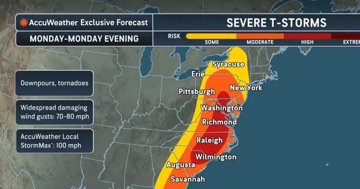
Warm air surging northward from the Gulf has triggered severe thunderstorms across the Deep South and parts of Texas. Radar imagery on Monday afternoon showed several rotating cells capable of producing long-track tornadoes. According to NBC News, meteorologists are monitoring a particularly dangerous situation near the Red River valley where supercells have developed. Local sirens have been active for hours in suburban communities, urging residents to seek shelter in basements or interior rooms. High-resolution satellite data indicates that the atmospheric shear is among the highest recorded for this time of year. Damage reports from northern Texas describe snapped power poles and destroyed outbuildings.
The speed with which this system is intensifying has caught many local emergency managers off guard as they scramble to set up shelters.
The threat of hail has caused large damage to automotive dealerships and residential roofing. Some reports indicate hailstones the size of baseballs falling in parts of Kansas and Oklahoma. The tornado risk remains the most pressing danger as the sun sets and visual confirmation of funnels becomes impossible. Nighttime tornadoes are notoriously more lethal because residents are often asleep or unable to see the approaching danger. Mobile phone alerts have been the primary method for disseminating urgent warnings to the public. National Guard units have been placed on standby in three states to assist with search and rescue if a major touchdown occurs.
Power Outages Spread Across States
Utility data shows that 500,000 residents are now without power as the storm system tears through the electrical grid. Texas reported the highest number of initial outages due to high-wind events that knocked down aging distribution lines. Energy providers in the Northeast are already bracing for a similar scenario as the storm moves into their service areas. Repair crews are being prepositioned in strategic locations, though high wind gusts often prevent technicians from using bucket trucks for safety reasons. Most outages are attributed to falling trees that have been weakened by a combination of saturated soil and intense gusts. Customers in rural sections of the Appalachian Mountains may face several days of darkness.
Even the energy industry is working to stabilize the grid to prevent cascading failures. But the large geographic scale of the damage is stretching available manpower to the limit. Mutual aid agreements have been triggered, bringing in electrical workers from as far away as Canada to assist in the restoration effort.
Heavy rains are expected to inundate New York City by early Tuesday morning, prompting a flurry of flood watches. The combination of rapid snowmelt in the Catskills and five inches of predicted rainfall creates a dangerous scenario for the Hudson River. City officials have begun installing temporary flood barriers in low-lying parts of Lower Manhattan and the Rockaways. The subway system remains vulnerable to water intrusion if the drainage pumps cannot keep pace with the downpour. Residents in basement apartments have been warned to move their belongings and prepare for possible evacuation. The Department of Environmental Protection is clearing catch basins to reduce the risk of street-level ponding.
At the same time, coastal communities are watching the tide cycles with growing anxiety. A storm surge of three to four feet is possible if the wind direction aligns with the high tide on Tuesday afternoon. Marine traffic in New York Harbor has been restricted as sea conditions deteriorate and wind speeds climb. The city has not seen a storm of this particular path in several years, leading to concerns about the readiness of newer drainage projects. Water levels in the East River are already nearing the tops of bulkhead walls. Every major bridge and tunnel in the metropolitan area is under a high-wind advisory that could restrict commercial truck traffic.
One Weather System Created Many Hazards
Why does the American public continue to treat these multi-state weather catastrophes as freak accidents of nature rather than predictable systemic failures? We are now observing a nation that builds for a climate that no longer exists, clutching to 20th-century infrastructure while 21st-century physics tears it apart. The recurring collapse of the Texas power grid and the predictable flooding of New York City subways are not tragedies of bad luck; they are indictments of a political class that prioritizes short-term budget cycles over long-term civilizational hardening.
We dump billions into disaster recovery while penny-pinching on the very upgrades that would make such recovery unnecessary. This storm is a brutal demonstration of the gap between our technological arrogance and our physical vulnerability. If the United States cannot maintain a functional power grid during a standard, albeit severe, late-winter front, it has no hope of weathering the far more unstable atmospheric shifts that data clearly indicates are coming. We are in practice watching a slow-motion demolition of the American lifestyle, one power outage and one flooded basement at a time.
The real disaster is the refusal to admit that the baseline for safety has shifted permanently beneath our feet.