NASA's Artemis II photo release gives the public a rare human view of the lunar far side while giving mission planners new visual context for future landings. The pictures matter because they are not only promotional images; they also document terrain, lighting and geological features from a crewed flyby.
The release on April 7, 2026, included high-resolution frames of Earthset, the lunar horizon and far-side surface features. That combination makes the gallery useful for science, public engagement and the next phase of the Artemis program.
Geological Survey and Artemis II Technical Data
Mapping the lunar far side requires more than automated satellite telemetry. Crewed missions allow for real-time identification of mineralogical anomalies that machines might overlook. According to NPR News, the crew took geological observations of places of interest on the lunar surface using their own eyes while snapping thousands of photos. These photographs reveal the rugged, crater-dense terrain that characterizes the side of the moon facing away from Earth. Modern optics allowed for a depth of field that highlights the elevation changes within the Aitken Basin.
Orion cameras functioned perfectly in the high-radiation environment of trans-lunar space. Engineers designed these systems to withstand the thermal fluctuations encountered when passing from direct sunlight into the lunar shadow. Each camera body featured customized shielding to prevent sensor noise during long-exposure shots of the lunar eclipse. Data packets transmitted back to Earth during the flyby totaled several terabytes of raw image information.
The astronauts aboard Artemis II are the first humans to see some parts of the far side of the moon with the naked eye.
Far Side Visibility and the Human Experience
Sunlight reflecting off the lunar surface provided the necessary illumination for the crew to capture the dark side during their closest approach. While satellite imagery often looks flat due to nadir-angle photography, these crew-captured photos offer oblique perspectives that reveal the height and scale of lunar mountains. Visual data from the mission will serve as a baseline for all future lunar surface operations. The sheer volume of photos suggests a heavy emphasis on public engagement as much as scientific rigor.
Observations from the naked eye helped the crew verify the accuracy of the automated star-trackers used for navigation. If the onboard computers failed, the astronauts would rely on these visual landmarks to guide their return to Earth. NASA technicians spent years training the four astronauts in professional-grade photography to maximize the scientific return of this flyby. They used specialized filters to cut through the glare of the sun when capturing the solar eclipse from the perspective of the moon.
White House Media Strategy and National Interest
Political leaders in Washington used the image release to reinforce the strategic importance of the Artemis program. The New York Times confirmed that the White House played a central role in the timing of the photo gallery publication. Presenting these images to the world serves to justify the billions of dollars spent on the Space Launch System and the Orion spacecraft. High-definition video clips accompanying the still photos show the crew reacting to their first glimpse of the lunar far side.
Public interest in space exploration often fluctuates based on the quality of the visual content provided by NASA. By releasing thousands of photos, the agency ensures a long-term presence in the global news cycle. Analysts suggest that the detailed imagery of the lunar surface is intended to showcase American technological dominance in the new space race. Every crater and ridge captured in these frames is a potential territory for future research outposts.
Geological interest remains high for the Schrödinger Basin, a location the crew photographed extensively. This region contains evidence of relatively recent volcanic activity and deep lunar crust materials. High-resolution imagery confirms the presence of distinct layering in the walls of central peaks within the larger craters. Geologists at the Johnson Space Center are currently cataloging every pixel of the new data. For a detailed account of the mission's earlier milestones, read how the Artemis II crew reached the far side of the moon.
Direct human observation provides a qualitative context that remote sensors lack. CBS News reported that the astronauts documented parts of the far side that had remained hidden from human sight for five decades. Looking directly at the lunar surface allowed the crew to notice subtle color variations in the regolith. These details indicate different mineral compositions, such as iron-rich basalt or aluminum-heavy anorthosite. Sunlight hitting the peaks of eternal light at the lunar poles created stark shadows that helped the crew estimate the depth of nearby craters.
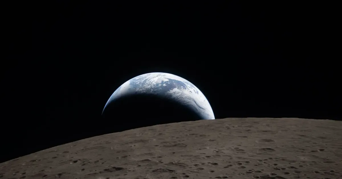
Earth appeared as a fragile blue marble against the absolute blackness of the void. Visualizing the solar eclipse from this vantage point required precise timing as the Orion spacecraft moved through the moon's shadow. The resulting images show the sun's corona flaring behind the dark disk of the Earth, a sight never before recorded by human hands in deep space. National pride and scientific curiosity converged as the images hit the internet on April 7, 2026.
Images Matter When They Guide the Next Mission
The strongest case for the release is practical. If the images help refine landing-site choices, train crews or explain terrain that robotic maps flatten, they add value beyond spectacle.
That is the standard NASA now has to meet. A striking lunar image can build public support, but the mission earns its place when the view becomes guidance for the next crew.