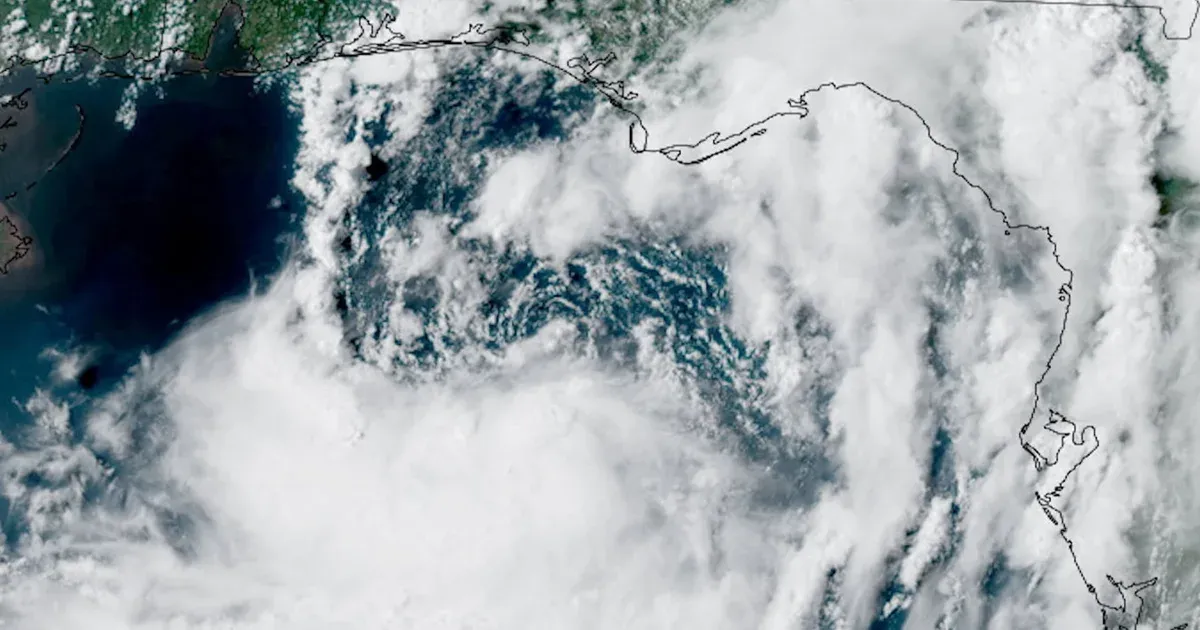
Tropical Storm Bertha is edging west along the northern Gulf Coast. A broad field of rain is reaching communities well ahead of its center. Forecasters expect the system to weaken, but its slow movement extends the period for flooding and coastal water to build. Warnings stretch across western Florida, Alabama, Mississippi and Louisiana rather than focusing on a single landfall point.
On July 21, 2026, Bertha's sustained winds reached 60 mph as it moved west at about 6 mph. Panama City was approximately 120 miles northeast of the center, while Mobile was about 105 miles to its northwest on Tuesday evening. A gradual loss of strength was forecast from Wednesday through Friday.
Bertha's Slow Westward Track Extends the Rain Window
The storm was expected to remain near the coast instead of crossing quickly inland. Its projected path runs west or west-northwest through Friday, carrying the circulation from the Florida Panhandle toward Louisiana and then closer to Texas. Even if the wind field weakens, that route can repeatedly feed moisture into the same coastal belt. A forecast line traces the center, not the outer edge of hazardous weather; rain spreading north and east of that line can affect communities that never come close to the circulation.
Meteorologist Michael Buchanan placed the expected Wednesday night coast crossing below New Orleans, in a sparsely settled stretch of Louisiana. The exact crossing point matters less for rainfall than it would for a compact, fast-moving storm, because Bertha's clouds already span several states. Communities east of the center can receive damaging weather hours before the circulation reaches land, while areas farther west remain exposed as the storm advances.
Only Arthur received a name earlier in the 2026 Atlantic season. That June system produced flooding across the Gulf states; the site's account of Arthur's Gulf Coast flooding shows how water can remain dangerous after a storm loses its name and wind strength. Bertha's weakening forecast therefore does not end the threat attached to its rain bands.
Warnings Span Four States and New Orleans
The eastern boundary of the warning sat where Florida's Bay and Gulf counties meet, while the western end reached Morgan City in Louisiana. New Orleans and Lake Pontchartrain were included separately. Areas continuing toward Cameron from Morgan City had watch status, as did Lake Maurepas. A warning means tropical storm conditions are expected in the designated area; a watch means they remain possible. The split reflects confidence and timing, not a hard boundary beyond which Bertha has no effects.
The warning area was scheduled to remain active through Wednesday, with rain and flooding possible into Thursday morning. Conditions had begun reaching parts of the Florida Panhandle on Tuesday afternoon. At Orange Beach, Alabama, red flags cautioned swimmers about surf and currents; emergency officials in Escambia County, Florida, offered sand to residents of flood-prone neighborhoods for sandbags.
Winds near 60 mph are capable of bringing down weak branches, disrupting power and making bridges hazardous. Bertha was not forecast to become a hurricane, and the center expected little change in intensity before weakening. The hurricane center kept tropical storm conditions in the coastal forecast because damaging wind reaches well beyond the compact point marking Bertha's center. That difference is important for preparations: the storm's category does not support the same wind assumptions as a major hurricane, yet it does not remove localized risks around exposed roads, low bridges and saturated ground.
Water, Not Wind, Drives the Main Hazard
Rain totals of three to five inches were forecast along the Louisiana coast, with isolated places potentially reaching six inches. Through Friday, places between Florida's western shoreline and central Texas faced a risk of sudden flooding. A wide forecast range reflects the uneven nature of tropical rain bands, which can leave one location with manageable totals and overwhelm drainage a short distance away.
Coastal water could rise as much as four feet in portions of Louisiana, Alabama and Florida. CBS reported that an earlier storm surge watch had been discontinued, but the expected water rise was still part of the hazard forecast. Residents should distinguish between the formal watch status and the underlying risk: removal of one alert does not mean every inlet, bay and low road is safe. Where heavy rain reaches the coast at the same time as elevated water, drainage can slow because runoff has less room to flow into bays and channels.
Forecasters also warned that Bertha could produce one or two isolated tornadoes over Florida's Big Bend. Such tornadoes are usually brief and difficult to place far in advance, giving local warnings more practical value than the broad storm track. The same applies to flash floods, which depend on where the heaviest bands stall and how quickly drainage systems fill.
Bertha's declining wind forecast may make the storm appear less urgent as it approaches Louisiana. The longer exposure to rain, four-foot coastal rise and possibility of short-notice tornadoes point in the opposite direction. For communities under warnings, the decisive information will come from local flood and tornado alerts as each band crosses, not from a lower wind number at the storm's center.