The remnants of Tropical Storm Arthur pushed dangerous weather across multiple parts of the United States, flooding homes along the Gulf Coast while severe storms damaged communities farther inland. The system had weakened, but the public-safety burden did not weaken with it. Emergency managers were dealing with a moving threat, not a finished storm, and that distinction matters for warnings.
CBS News and AP reported on June 18, 2026, that Arthur's leftovers brought drenching rain, strong wind, water rescues and evacuations across parts of the southeastern United States. Separate severe storms also produced tornado reports in the Midwest and Southeast, toppling trees and shredding buildings in the path of the line.
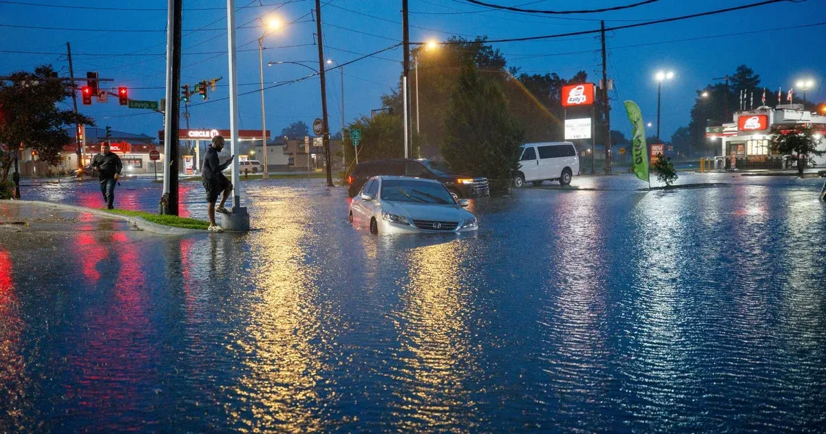
Tropical Storm Arthur's remnants are a reminder that the danger from a named storm does not end when the headline category fades. Heavy rain can stay organized, drains can fail, low roads can disappear and emergency crews can spend the next day rescuing people from homes or vehicles.
Flooding Was the Immediate Threat
The Gulf Coast impact centered on water. Flooding is often less visually dramatic than a landfall map, but it is one of the fastest ways a storm turns from weather into a local emergency. Homes take water, roads close, power crews lose access and first responders have to decide which calls can wait.
That pattern is especially dangerous when residents hear that a storm is no longer at peak strength. A weakened system can still unload enough rain to trap families in neighborhoods that normally drain well. It can also push water into places where people have already let their guard down, especially when the worst conditions arrive after sunset or after local roads have already started to fail.
The same national weather pattern carried severe storm energy into the Midwest and Southeast. Tornado reports and wind damage add a second strain on emergency systems, because cleanup crews, shelters and utility teams are no longer dealing with one clean disaster zone.
Warnings Have to Beat Fatigue
Storm fatigue is a real operational problem. By the time remnants move inland, people have heard days of forecasts and may assume the worst has passed. That is exactly when flash flooding can become more lethal, because the threat moves from satellite imagery to a flooded road at night.
Water rescues are also a sign that public warnings did not fully translate into behavior or that conditions changed faster than people could react. In flood events, the dangerous decisions are often ordinary ones: trying to reach work, checking on a relative, moving a vehicle, or assuming a familiar road is still passable. Either way, emergency managers now have to communicate in a way that treats post-landfall flooding as the main event, not the afterword.
Recent coverage of Mississippi storm damage showed the same weakness in the national weather conversation: warnings often describe hazards accurately, but the public remembers the single most dramatic label. Tornado, tropical storm and flash flood are different words for the same practical question: can people stay safe where they are.
The Cost Comes After the Cameras Leave
The hard part starts after the water drops. Families have to deal with damaged floors, spoiled belongings, insurance calls, closed roads and uncertain repairs. For local governments, the cost is not only cleanup; it is shelter capacity, debris removal, damaged culverts, overtime and the pressure to restore normal life before the next round of storms appears. Local governments have to count damage while still answering routine emergencies. Arthur's remnants should not be treated as a minor storm footnote. The system exposed how little margin many communities have when rain, wind and tornado risk arrive in overlapping waves. A place does not need a record-breaking storm to be overwhelmed; it only needs the wrong hazards arriving close together.
The blunt lesson is that severe weather now punishes weak preparation more than weak vocabulary. Calling a storm a remnant does not make flooded homes less real. If officials and residents treat the downgraded label as permission to relax, the storm has already found its opening. The next forecast cycle will not matter much if people learn the warning only after the water reaches the door.