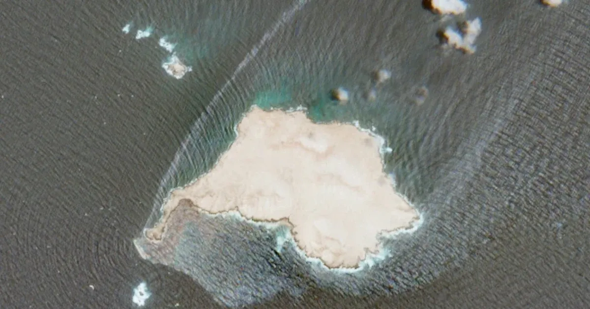
Oil leaking from a grounded tanker off Oman has spread across open water and reached the shores of Qibliyah Island, turning a stranded-vessel problem into a widening environmental response. Satellite images reviewed by The Associated Press show both a broad surface sheen and darker patches along the island's coast. The latest assessment was published on August 4, 2026, after monitors compared images taken one week apart.
Greenpeace Germany calculated that Sunday's image set contained petroleum across roughly 150 square kilometers, or 58 square miles, of sea. The corresponding estimate from one week earlier was 20 square kilometers, or 8 square miles. The comparison does not establish how much oil entered the water, but it shows a sharp increase in the area where petroleum was visible. The organization released its assessment on Monday, and the August 4 AP account did not identify what caused the sudden expansion.
Satellite Measurements Trace the Leak From Ship to Shore
The source of the spill is the Caroline Bezengi, a 274-meter Suezmax tanker that has been grounded off Oman since June. Satellite imagery showed the sheen moving northeast from the vessel. Wim Zwijnenburg of the Dutch organization PAX estimated that it extended roughly 90 kilometers, or 56 miles, nearly twice the length measured a week earlier. His reading put the amount of crude aboard before the incident above 800,000 barrels. Those figures describe the scale visible from orbit and the estimated cargo aboard the stranded ship; they do not establish that the full cargo has leaked.
The satellite record separates two forms of exposure. A thin sheen can spread over a large surface and may evaporate depending on the crude and weather, Zwijnenburg said. On Qibliyah's south and west coasts, the imagery showed heavier black deposits rather than only a surface film. That distinction matters because the 150-square-kilometer spill footprint is not a uniform layer of heavy oil, while shoreline deposits create a more concentrated cleanup problem.
Qibliyah lies within a protected Arabian Sea reserve off Dhofar, Oman's largest governorate. Rare Arabian Sea humpback whales use these waters, as do endangered petrels. The available report did not quantify harm to animals or describe a completed wildlife survey, so the confirmed finding is exposure of protected habitat rather than a measured casualty count.
Two maritime publications reported that the crew had described an explosion aboard the tanker when it became stranded in June. The AP said it could not independently confirm those accounts. The cause of the vessel's grounding and the reason the leak expanded so rapidly remained unresolved in the August 4 AP account. That leaves a firm visual record of the spread but an incomplete account of the mechanical event that preceded it.
The ship's sanctions history adds a second track to the incident. Britain sanctioned the tanker over Russian-origin oil and activity judged capable of supporting the Russian government or destabilizing Ukraine. Separate listings in the European Union, Canada and Switzerland cover the ship, which is registered under Cameroon's flag. Satellite data obtained by SynMax Maritime located the vessel in May at Novorossiysk, a Russian port on the Black Sea, before it sailed on the journey that ended off Oman.
Oman's Removal Order Is Now an Environmental Deadline
Muscat Daily reported that the Omani transport ministry set July 23 for the owners to take away the stranded vessel and its remaining cargo. The AP report said it was unclear whether the owners had replied. It was also unclear where the Caroline Bezengi was headed when it grounded, leaving the voyage's intended destination outside the confirmed record. The order covered the stranded hull and the oil still aboard it, linking the maritime clearance problem directly to the pollution risk.
The July 23 removal deadline provides a concrete measure of the response: the order had already passed before the spill's visible area expanded. Removing the cargo, stabilizing the ship and addressing oil that has reached shore are separate tasks, and the latest AP account did not confirm completion of any of those steps.
The immediate test is therefore not the sanctions label alone but whether the responsible parties can stop further leakage and carry out the removal order. Satellite measurements can show whether the surface area is shrinking or growing, while shoreline observations can track the heavier deposits around Qibliyah. Until those indicators improve, the tanker remains both a maritime obstruction and an active source of risk inside protected waters.